Gloucester Aero Club
Gloucester Aero Club
NB: This does not
replace good Airmanship! This information is provided in good faith, accuracy is not guaranteed and is for guidance only
![]()
![]()
S32.03.05 E151.58.34
RWY 17/35, 840 m, Orange indicates fly over only.

![]()

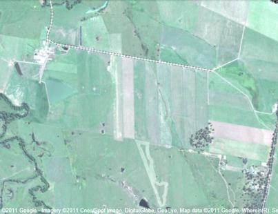
Runway Direction: 17 / 35
Elevation: 420’
Length: 840m Short Grass
Note: The strip is in great condition and regularly maintained
however at the Northern end 140m (to north of dirt road crossing strip) should
be considered fly over as the surface is not as well maintained. Slope:
1 degree down on RWY 35 Obstacles:
Some tall gum trees south of the RWY 35 threshold Area
Communication: Brisbane Centre 120.55 Multicom: In the Circuit use 126.7 (although
not a registered CTAF) Procedures: All Aircraft, Circuits to West,
Standard Circuit height Windsock: One
in south eastern corner, one at north western end on the clubhouse Caution:
Williamtown Restricted Airspace is the adjacent and overlying
airspace. We are in the light
aircraft lane to the west of Williamtown, see the VTC series charts. Prior
Permission Required: Contact Chris Maslen 0428 582718 Note: Permission not required for
club meetings or special events Landing Fee: Nominal charge is $10 in letterbox
by the clubhouse door. Club
Facilities: Available on request; Clubhouse
and limited hangarage with limited bunk
accommodation, full Kitchen / Bathroom facilities. Camping available with
use of club facilities at nominal charge. Fuel:
Limited fuel is
available from drums in emergency.